Mt. Deo Tibba Expedition : 2024

0 (0 Reviews)
Himtrek's Riverside Camps and Hostel, Manali
From: ₹ 59,999
0
(0 review)
Inquiry
Duration

12 Nights 13 Days

Cancellation

Up to 10 days

Group Size

12 people

Languages

English, Hindi

About this activity

Mt. Deo Tibba Expedition: Overview

Mt. Deo Tibba Expedition peak, is located in Himachal Pradesh’s Kullu valleys Pir Panjal Range is the second-highest peak and stands an astonishing 6,001 metres above sea level. The Deo Tibba is thought to be the meeting place for all gods (devtas), who are said to congregate and sit atop this hill to address topics of the utmost significance.


Fix Departure Date – 2024
September  7th(6 Seats)  14th (8 Seats)

Note : Date Can Be Customize for 4 Or More People

Read More

It is located southeast of Manali above the village of Jagatsukh. Putting the legends aside, we like it because of its eccentricity. The sole adjective that describes its erratic personality is “temperamental.” Its intense moods, more than the fact that they are constantly changing, are what make it eccentric.

With two vertical ice gullies and an ice cap on the route to the top, the trek begins in Manali, a popular destination for backpackers, and it qualifies as a rigorous mountaineering excursion.

The track leads to the base camp of this spectacular peak through the most beautiful terrain, including expansive meadows with the most stunning display of colourful wild flowers, a panoramic view of the entire mountain range, and dramatic cloud formations that can be seen all along the way. We reach a scene of boulders, moraine, and slowly appearing snow that quickly covers the entire mountain’s surface as the vegetation begins to dwindle.

The steep descent to Duhangan Col is one of the climb’s more interesting (and difficult) sections. The col has a well-established reputation. It is as terrifying as it sounds if you’ve heard the stories about the col.

The peak of Mount Deo Tibba, which separates it from neighbouring mountains and is shaped like a dome, is another fascinating feature of the mountain. Unlike other summits, which are sharp, singular points, this summit is flat and more plateau-like.

The trek has some tough aspects that call for special expertise because they necessitate negotiating vertical ice gullies. Fixed ropes and specific climbing gear are needed to navigate these 60–70 degree grades. Mt. Deo Tibba expedition is intended for seasoned hikers with prior experience using mountaineering techniques including the usage of ice axes, crampons, descender, jumar, and roping up procedures. This is because of the mountain’s difficult terrain and expedition-style climb. This adventure is ideal for any ambitious mountaineer hoping to climb higher in the near future and wanting to reach a height of 6000 metres or more.

Quick Facts:

Region: Manali, Himachal Pradesh

Mt. Deo Tibba Expedition Start/End Point of the Trek: Manali

Mt. Deo Tibba Expedition Duration: 13D/12NHeight: 19700ftMt. Deo Tibba Expedition Distance: 60 km

Mt. Deo Tibba Expedition Difficulty Level: Difficult Trek

Mt. Deo Tibba Expedition Temperature: Day (10°C to 15°C) and Night (-2°C to 5°C)

Best time Mt. Deo Tibba Expedition: Mid June to October

What is the Best time to visit Mt. Deo Tibba Expedition?

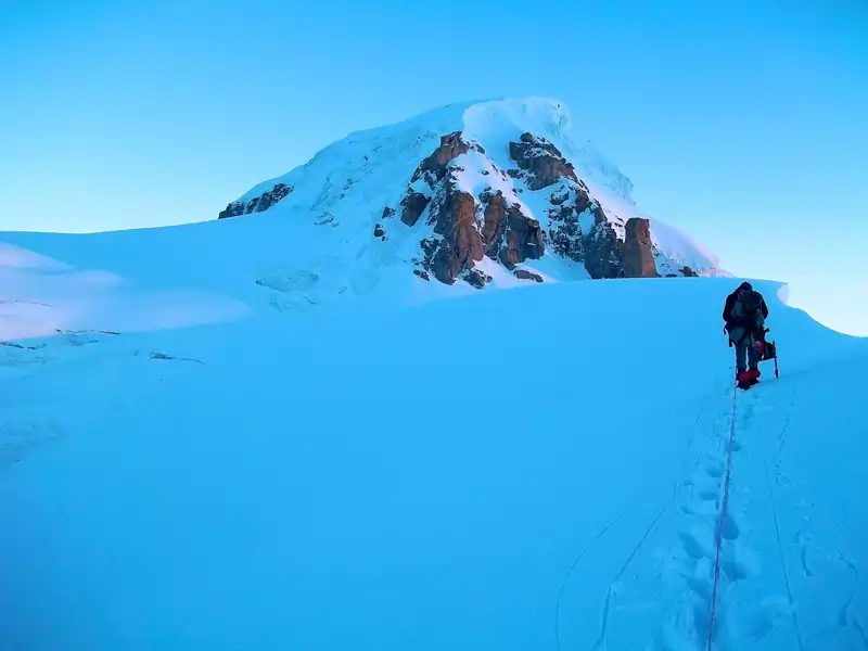
As the trekkers move upward, Deo Tibba presents a difficult ascent and descent. Mid May to October are the finest months for trekking these pathways. The trek falls into the category of pre- and post-monsoon excursions because of the unfavourable weather conditions.

What’s the Difficulty Level of Mt. Deo Tibba Expedition?

The trek is of difficult grade. We strongly advise a reasonable degree of physical fitness due to the top’s rather high height. Acclimatisation is necessary because of the difficult Deo Tibba Expedition’s requirement of covering more distances and higher elevations in a shorter amount of time. Before beginning the trek, we urge hikers to psychologically and physically prepare themselves.

Can we Rent Equipment for Mt. Deo Tibba Expedition?

Himtrek does provide easy accessibility to almost all types of equipment required for the trek on a rental basis with reasonable prices and extremely good quality. The equipment can be arranged on prior notice.

How is the Weather during Mt. Deo Tibba Expedition?

Depending on what time of year trekkers are going, different weather conditions exist. Pre- and post-monsoon months feature average daytime temperatures and noticeably colder nights. Weather conditions can become more difficult as elevation rises.

What is the Distance of Mt. Deo Tibba Expedition?

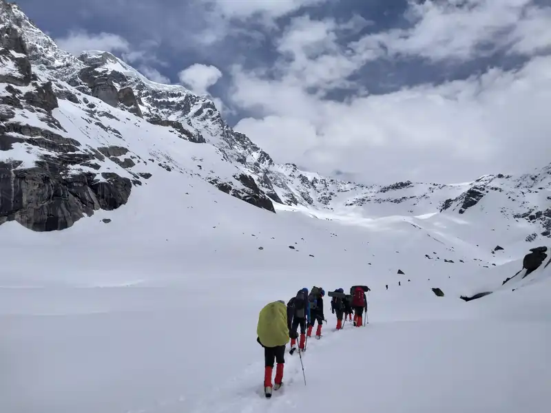
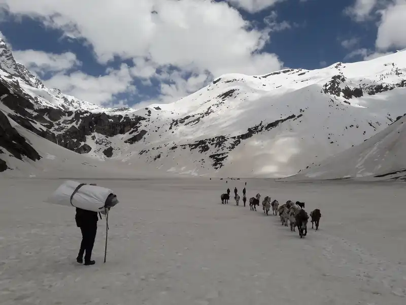
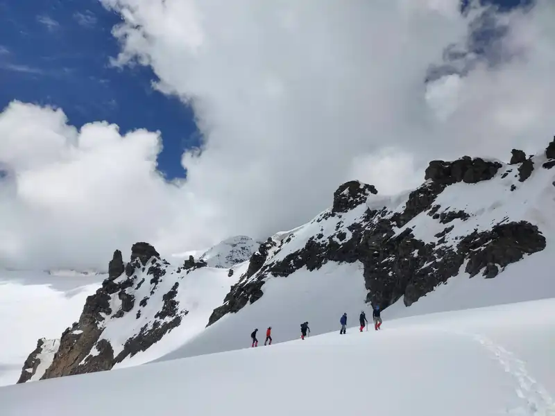
The trek is 60 km long and the highest point is at 19,700 ft altitude. The challenging nature of the trek exists due to such high altitude and the long distance accompanied by variable weather conditions.

What is the Height of Mt. Deo Tibba Expedition?

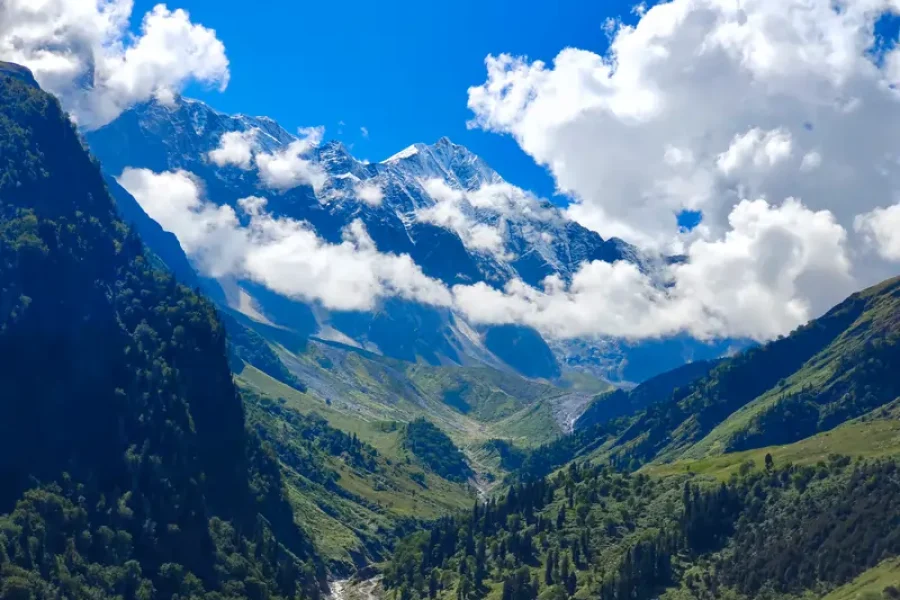
The Mt. Deo Tibba Expedition is a challenging trek in the Indian state of Himachal Pradesh, located in the Pir Panjal range of the Himalayas. Mt. Deo Tibba itself stands at an impressive height of 6,001 meters (19,688 feet) above sea level, offering adventurers breathtaking views and a thrilling climbing experience.

When is the best time  to hike Mt. Deo Tibba Expedition?

The best time to trek Dev Tibba Mountain is during the summer months from May to June and the light rainy season from September to October, when the weather is good and the trails are available

Is altitude sickness a concern when traveling?

Altitude sickness can affect hikers who climb to higher elevations. A healthy environment, a hydrated lifestyle and gradual climbing are important to reduce the chances of altitude related diseases.

Are there campsites along the trail?

Yes, there must be campsites at specific campsites along the hiking trails. Pedestrians can easily appreciate the comfortable tents, healthy food and simple offerings in the middle of the desert.

Can beginners do the Mt.Deo Tibba Expedition?

While Mount Dev Dunes is an intense hike suitable for professional hikers, beginners with fitness and objective credentials can experience the day with proper education and guidance.

What wildlife might you encounter on the trip?

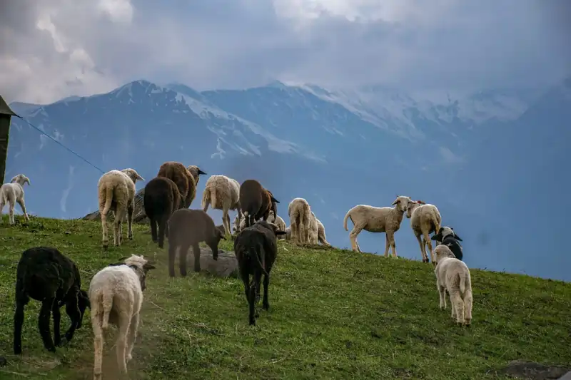
Mount Dev Dunes has a variety of flora and fauna including Himalayan birds, wild flowers and occasional sightings of Himalayan wildlife including snow leopards and blue sheep.

How long does it take to complete the walk?

The length of the Mount Deo Tibba trek varies depending on factors including trek tempo, weather conditions and acclimatization breaks It usually takes about 8-10 days to complete a roundabout experience trek

How to Reach Basecamp -Manali

By Road:

The quickest and most economical way to get to Manali. Manali is accessible by road from several locations, including Delhi (540 km), Chandigarh (305 km), Dehradun (227 km), and Ambala (370 km).

By Train:

The closest railway station to Manali is Jogindernagar. Other train routes to Manali include those through Chandigarh and Ambala.

By Air:

The nearest airport is Bhuntar airport, 10 km from Manali. Cabs and local buses are easily available from Bhuntar to Manali.

12 Nights 13 Days Available on request

After completing the trek, why not extend your adventure and spend some time in Kasol with Himatrek stays?

Himtrek Stays in Kasol

Himtrek has cozy and comfortable places to stay in Kasol. After your trek, you can rest and relax at these places. Himtrek has small guest houses and nice homestays. There are different options for all kinds of travellers.

In Kasol, you can experience the interesting culture. You can explore the mall road . At the Himtrek stays, you can have peace in nature or enjoy cultural activities. Himtrek stays in Kasol give you comfort and adventure.

Himtrek offers a wide range of accommodation options in Kasol to suit the needs and tastes of every traveller. Whether you’re looking for a cozy guesthouse in the middle of a pine forest or a comfortable hostel with a lively atmosphere, Himtrek is the place for you.

So pack your bags, lace up your boots, and embark on an unforgettable journey into the heart of the Himalayas, and stay in

Himtrek Stays in Kasol

For more adventure and information click here :https://himtrekstays.com/

Kindly review the Terms and Conditions before proceeding with your booking.

Highlights

  • Explore and summit the second highest peak of Pir Panjal ranges.
  • Discover the various snow-covered peaks visible from the top in a panoramic view.
  • The mountain stands out because it has a flat top plateau rather than a pointed ridge and a snow dome summit that resembles an ice cap.
  • Encounter with challenging terrain, such as steep ice passages, crevassed glaciers, a rockfall region, and a ridge.
  • Test the limits of your physical and mental endurance.
  • An accomplishment in and of itself is the Snow Dome near the finish of this adventure.
  • Get the adrenaline boost of climbing the trekker’s “to-do-list” summit!!

Included/Excluded

  • Accommodation on sharing basis.
  • All Meals (Veg), Including from Packed Lunch on the 1st day to Breakfast on the 13th Day.
  • Well Qualified Trek Leader.
  • Supporting Staff and cook.
  • Forest Permits.
  • Basic Medical Kit.
  • Accommodation on Tent Stay.
  • Camping and Trekking Equipment (Tent, Sleeping bags, Crampons, Ice axe etc).
  • Anything which is not included in the above inclusion.
  • Porters or Mule to carry your personal Luggage.
  • Any kind of Personal Expenses.
  • Personal Medication.

Itinerary

Day 1: Arrival at Manali Campsite

  • The adventure begins at the town of Manali, a very well-liked and easily accessible tourist destination.
  •  The first half of the day is spent getting acquainted with one another and the mountain air.
  • At night, spend your time taking proper rest and relaxing your bodies as the trek starts tomorrow.

Day 2: Manali to Chhikka

  • Today, we'll be travelling to Chhikka's vast fields.
  • We will need to drive up to the trailhead, Khanol, which is where the Duhangan Hydro Project is located
  • The journey up 40 hairpin curves takes you to Khanol.
  • The hike along the Jagatsukh Nala through forested terrain from Khanol to Chhikka is brief and delightful.
  • Reach your campsite and unwind for the rest of the day. Spend the night there at campsite.

Day 3 : Chhikka to Seri

  • Today, after breakfast, we at 9 AM. Along the Jagatsukh Nala
  • The ascent from 3,175M to 3,700M is gradual.
  • The Tanita cliffs, which tower to the left and have waterfalls tumbling on the rocks below, 
  • Spend the night camped on the flatlands. The dome of Deo Tibba will be visible for the first time at this time.

Day 4: Seri to Deo Tibba Base Camp

  • Between 9 and 10 AM, we set out across Seri's level meadows, followed by a stream crossing.
  • Today's hike is more difficult, starting on a level path across the Seri grasslands.
  • Continue along the Jagatsukh River, encountering a waterfall and a nearby boulder.
  • After crossing the river, ascend a steep, zig-zag trail to Tainta Cliff for 2-2 1/2 hours.
  • The two-hour ascent leads to Chota Chandratal, a small lake where the campsite is located in a closed valley.

Day 5: Rest and Acclimatization day

  • Get up this morning and relax. It's critical to give your body enough time to acclimatise considering that we have ascended to 4200 metres in elevation.
  • You increase your chances of getting altitude sickness if you are increasing altitude quickly and do not plan enough time to acclimatise.
  • This encourages the physiological adjustments your body has to make to the environment and the lower oxygen intake at higher elevations.
  • Also, inform your trek leader right away if you exhibit symptoms of AMS.
  • There will be briefings on the summit procedure and upcoming events in the evening.

Day 6: Load ferry to Camp 1

  • Mountaineering starts today.
  • A load ferry is crucial when mountaineering. 
  • Take the appropriate acclimatization steps 
  • You will transport your belongings to camp 1 today and return to base camp for the night.
  • The terrain is challenging and begins with a 200 m moderate incline before becoming steep for 300 m, then flat for 100 m.
  • The location of Camp 1 is on Duhangan Pass.
  • Watch your steps because the glacier has a lot of crevasses. 
  • After you've loaded everything, eat lunch at camp 1 and get ready to descend. Tents will be used for lodging at Base Camp.

Day 7: Deo Tibba Base Camp to Camp 1

  • Your official transition to camp 1 will take place today. The path you took yesterday is what you should take today.
  • Be careful when crossing rocks and in areas where there are rockfalls and glaciers.
  • The ascent will take roughly 5 to 6 hours. Make sure to rest adequately and avoid overworking your body. Once you reach camp 1, stay in tents.

Day 8: Load ferry to Summit Camp

  • Move on up to the highest camp now. However, it will just be loading the ferry and returning to Camp 1.
  • The load ferry concept is used once more to avoid altitude-related problems and to assist your body acclimatize to the shortage of oxygen because altitude-related sickness is a possibility as we are gaining quite a deal of height in a short period of time.
  • Snow covers the entire trail on today's trek. Therefore, it is vital to wear all of your snow gear and clothing. The trail is significantly more challenging because of the snow.
  • For the first one hour, it is a moderate climb which later on becomes a steep climb. Follow the footsteps of your guide as he breaks the route open for you.
  • Spend little time on the summit camp, and have lunch so that your body starts acclimatising. Again retrace your steps back to camp 1. Stay the night in Camp 1 and rest your body well.

Day 9: Camp 1 to Summit Camp

  • The entire team is headed to summit camp today. Bring only what you will actually need and leave the rest at camp 1.
  • We visit the campgrounds twice for Deo Tibba: once during the load ferry when we carry our belongings to Camp 1 and then back to the lower campsite, and once between Camp 1 to the summit camp and then back to Camp 1.
  • This offers many advantages. To avoid having to carry a heavy load throughout the walk, you first divide the weight between two days.
  • Finally, every time you climb the same route, it gets easier and you get better at using your techniques and talents. This provides your body enough time to acclimatise to the high altitude conditions.
  • Your crew will give you a summit attempt briefing once you get to the camp. It's an excellent opportunity to review your knowledge of snow and ice.
  • The summit night will make for a spectacular evening. For the summit attempt, have a filling meal and get enough sleep.

Day 10: Summit Attempt and back to Camp 1

  • At two in the morning, the summit attempt will begin. To prepare for the summit push, get up at the appropriate time. The trek begins by using fixed ropes to bridge a gulley.
  • The rise in the first 300 metres is difficult and steep. Continue ascents up the snowy mountains. As you ascend, you can view the Indrasan Peak.
  • Just before the top, the slope becomes steeper. Actually, the summit is a huge snow dome that is open and level. As a result, the final 100 metres to the summit are practically level.
  • Near the conclusion, there are a lot of crevasses as well. While navigating the gully and ascending to the summit is doable, the main difficulty is breathing in the increasingly thin air as you continually ascend.
  • The summit is spacious enough to fit the entire squad. You can clearly see the Indrasen peaks and a mountain lake when you reach the summit. The vistas are simply breathtaking.
  • After attempting the summit, stay a little while there, celebrate your success, and then return to camp 1.

Day 11: Camp 1 to Deo Tibba Base Camp

  • It's time to begin the return trek after the summit attempt. To go to Deo Tibba Base Camp, stay on the same trail.
  • Be careful when you descend because it is steep. Be cautious and keep a steady pace as you descend because it can be hard on your knees.
  • Try to arrive at the Base Camp before noon. Your Trek Leader should receive all of your technical gear back. After an eventful day, relax in your tents.

Day 12: Base Camp to Chhikka

  • Start your journey home again. Trek backwards through the rocky moraines and steep slopes. Between turns, the path is flat and inclining.
  • In essence, you'll be returning to the same set of stairs. Since the walk is 14 km long, bring a packed lunch. Enjoy your final camping trip at Chhikka.

Day 13: Chhikka and back to Manali

  • The trek's final day has come. On the final day, you must retrace your travels using the very first path that you devised.
  • Gather all your memories, then bid the mountains farewell. Ride back to Manali after reaching Khanaul via the same trekking route.
  • You will arrive in Manali around lunchtime after a couple hours of driving and the accompanying trek. Have a happy celebration of your success and a safe trip home!

Activity's Location

Himtrek's Riverside Camps and Hostel, Manali
From: ₹ 59,999

Owner

HIMTREK

Member Since 2023

Explore other options